Madeira, a Portuguese archipelago located in the Atlantic Ocean, is renowned for its stunning landscapes, rugged coastline, and lush greenery, making it a paradise for hikers. The island offers a variety of trails that cater to different levels of experience and fitness. Here are my best 7 pickup hiking trails in Madeira:
1. Levada das 25 Fontes and Levada do Risco
Levada das 25 Fontes and Levada do Risco are two of the most popular hiking trails in Madeira, offering spectacular views, lush forests, and impressive waterfalls. These trails are often combined into a single hike, allowing visitors to experience both attractions in one trip.
Overview
- Location: Rabaçal, Madeira
- Distance: Approximately 11 km round trip (if both trails are combined)
- Difficulty: Moderate
- Duration: Around 4-5 hours
Levada das 25 Fontes
Highlights
- 25 Springs: The main attraction of this trail is the 25 Fontes (25 Springs), a series of natural springs that cascade into a tranquil pool. The site is surrounded by lush vegetation, creating a serene and picturesque setting.
- Laurisilva Forest: This trail takes you through the Laurisilva forest, a UNESCO World Heritage site known for its unique and diverse flora and fauna.
- Tunnel: The hike includes a short tunnel section, so bringing a flashlight or headlamp is recommended.
Route Description
- Starting Point: The hike typically begins at the Rabaçal parking area, where you can either walk down the road to the Rabaçal nature house or take a shuttle service.
- Rabaçal House: From the Rabaçal house, follow the signs to Levada das 25 Fontes. The path is well-marked and follows the levada (irrigation channel) through the forest.
- The Descent: The trail descends gradually, offering scenic views of the valley and surrounding mountains.
- Arrival at 25 Fontes: After approximately 4.5 km, you will reach the 25 Fontes waterfall. Spend some time here to enjoy the beautiful setting before heading back.
Levada do Risco
Highlights
- Risco Waterfall: The main feature of this trail is the Risco Waterfall, a majestic cascade that drops from a significant height into the valley below.
- Panoramic Views: The trail offers stunning views of the surrounding mountains and valleys.
Route Description
- Connecting Path: From the Rabaçal house, there is a clearly marked path that leads to the Levada do Risco. This trail is shorter, about 1.5 km each way.
- Following the Levada: The trail follows another levada, offering beautiful views along the way.
- Arrival at Risco Waterfall: The hike ends at a viewpoint overlooking the impressive Risco Waterfall. This spot provides an excellent opportunity for photography and relaxation.
Combining the Trails
Many hikers choose to combine both Levada das 25 Fontes and Levada do Risco into a single hike. This can be done in either order, but typically, hikers start with the longer 25 Fontes trail and then proceed to the Risco Waterfall on the way back.
Practical Tips
- Weather: Check the weather forecast before you go. The trails can be slippery when wet, and fog can reduce visibility.
- Footwear: Wear sturdy hiking boots with good grip, as some sections can be uneven and muddy.
- Gear: Bring a flashlight or headlamp for the tunnel, enough water, snacks, and a rain jacket.
- Navigation: The trails are well-marked, but carrying a map or GPS device is always a good idea.
- Shuttle Service: Consider using the shuttle service from the Rabaçal parking area to the Rabaçal house to save energy for the hike
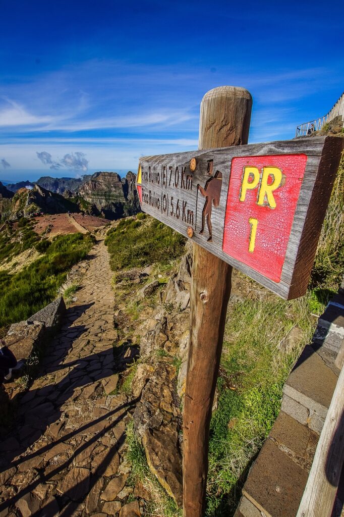
2. Hiking Pico Ruivo via Pico do Arieiro
The hike from Pico do Arieiro to Pico Ruivo is one of the most stunning and challenging hikes in Madeira. It connects two of the highest peaks on the island, offering breathtaking views of the rugged mountain landscape and deep valleys. Here’s an overview of the hike:
Overview
- Location: Central Madeira
- Distance: Approximately 12 km round trip (6 km each way)
- Elevation Gain: About 1,200 meters
- Difficulty: Hard
- Duration: 6-8 hours round trip
Highlights
- Pico do Arieiro: Starting at 1,818 meters, this is the third-highest peak in Madeira. The summit provides panoramic views and a chance to see the sunrise above the clouds if you start early.
- Pico Ruivo: The highest peak in Madeira at 1,862 meters. The views from here are spectacular, especially at sunrise or sunset.
- Dramatic Scenery: The trail features dramatic ridges, tunnels, steep ascents, and descents, with breathtaking vistas at every turn.
- Flora and Fauna: The trail passes through varied landscapes, including endemic plant species and occasional sightings of Madeira’s unique birdlife.
Route Description
- Starting Point: The hike begins at the Pico do Arieiro summit, which is accessible by car or taxi from Funchal. There is a parking area and a café at the summit.
- Initial Descent and Ascent: The trail starts with a steep descent followed by a series of ascents and descents along ridges. The path is well-marked but involves some steep and narrow sections.
- Tunnels and Staircases: Along the way, you’ll encounter several tunnels (bring a flashlight) and metal staircases. These sections add to the adventure but require caution.
- Ninho da Manta Viewpoint: About halfway along the trail, you’ll reach this viewpoint, offering stunning views of the surrounding peaks and valleys.
- Final Ascent to Pico Ruivo: The last section involves a steady climb to the summit of Pico Ruivo. The path here is more gradual and less exposed.
- Pico Ruivo Summit: At the summit, there is a shelter with basic facilities. Take time to rest and enjoy the panoramic views.
Practical Tips
- Weather: The weather in the mountains can be unpredictable. Start early to avoid afternoon fog and be prepared for changing conditions. Check the weather forecast before heading out.
- Gear: Wear sturdy hiking boots with good grip. Bring a flashlight for the tunnels, plenty of water, snacks, and a rain jacket. Sunscreen and a hat are also recommended.
- Physical Fitness: This hike is demanding due to its length, elevation changes, and the rugged terrain. Ensure you are physically prepared for a strenuous hike.
- Navigation: The trail is well-marked with signs and painted markers, but carrying a map or GPS device can be helpful.
- Transport: Arrange transportation back from the starting point if you are not returning the same way. Some hikers choose to hike one way and have a taxi or shuttle pick them up at the end.
Safety Considerations
- Exposure: Some sections of the trail are exposed with steep drop-offs. Exercise caution, especially in windy conditions.
- Tunnels: Some tunnels are dark and narrow. A flashlight or headlamp is essential for safe passage.
- Weather Conditions: Avoid hiking in adverse weather conditions such as heavy rain, strong winds, or fog, as these can make the trail dangerous.
3. Vereda do Areeiro
The Vereda do Areeiro trail is one of Madeira’s most iconic and scenic hikes, connecting Pico do Arieiro to Pico Ruivo, the island’s highest peak. This trail offers hikers stunning views, dramatic landscapes, and a challenging yet rewarding experience.
Overview
- Location: Central Madeira
- Distance: Approximately 7 km one way
- Elevation Gain: Around 1,000 meters
- Difficulty: Hard
- Duration: 3-4 hours one way, 6-8 hours round trip
Highlights
- Pico do Arieiro: At 1,818 meters, this is the third-highest peak in Madeira. Starting here offers panoramic views and an excellent opportunity to see the sunrise.
- Pico Ruivo: The highest peak in Madeira at 1,862 meters. The summit provides incredible 360-degree views of the island.
- Stunning Scenery: The trail traverses ridges, deep valleys, and dramatic rock formations. The landscape is rugged and spectacular.
- Flora and Fauna: The trail passes through diverse ecosystems with endemic plants and unique wildlife.
- Tunnels and Staircases: The route includes tunnels and staircases carved into the rock, adding to the adventure.
Route Description
- Starting Point at Pico do Arieiro: The hike begins at Pico do Arieiro, accessible by car or taxi. There’s a parking area and a café at the summit.
- Initial Descent: The trail descends sharply from Pico do Arieiro along narrow ridges with steep drop-offs. The path is well-marked but challenging.
- Tunnel Sections: You’ll pass through several tunnels. A flashlight or headlamp is necessary as some tunnels are dark and narrow.
- Ninho da Manta Viewpoint: About halfway through, reach this viewpoint with stunning vistas of the surrounding mountains and valleys.
- Steep Climbs and Descents: The trail involves multiple steep climbs and descents, with sections of stairs and narrow paths.
- Final Ascent to Pico Ruivo: The last part of the hike is a steady climb to Pico Ruivo. The path is less exposed but still challenging.
- Pico Ruivo Summit: Enjoy the panoramic views from the highest point in Madeira. There’s a shelter at the summit with basic facilities.
Practical Tips
- Weather: Weather in the mountains can change rapidly. Start early to avoid afternoon fog and check the forecast before you go.
- Footwear and Gear: Wear sturdy hiking boots with good grip. Bring a flashlight for the tunnels, plenty of water, snacks, and a rain jacket. Sunscreen and a hat are also advisable.
- Fitness Level: This hike is strenuous due to the elevation changes and rugged terrain. Ensure you are physically prepared for a demanding hike.
- Navigation: The trail is well-marked, but carrying a map or GPS device is recommended.
- Transport: Consider transportation logistics if not returning to the starting point. Some hikers arrange for a taxi or shuttle from the end point at Achada do Teixeira, a shorter descent from Pico Ruivo.
Safety Considerations
- Exposure: The trail includes sections with steep drop-offs. Exercise caution, particularly in windy or wet conditions.
- Tunnels: Some tunnels are dark and narrow. A flashlight or headlamp is essential for safe passage.
- Weather: Avoid hiking in poor weather conditions such as heavy rain, strong winds, or fog, which can make the trail dangerous.
4. Levada do Caldeirão Verde
Levada do Caldeirão Verde is one of Madeira’s most enchanting and scenic hikes, offering a journey through lush forests, alongside cascading waterfalls, and ending at the breathtaking Caldeirão Verde waterfall. This hike is ideal for nature lovers and those seeking a moderately challenging adventure.
Overview
- Location: Queimadas, Santana, Madeira
- Distance: Approximately 13 km round trip
- Elevation Gain: Minimal (mostly flat with some gentle inclines)
- Difficulty: Moderate
- Duration: 4-5 hours round trip
Highlights
- Caldeirão Verde Waterfall: The main attraction, this impressive waterfall drops into a deep, green lagoon, creating a serene and picturesque setting.
- Laurisilva Forest: This hike takes you through Madeira’s ancient Laurisilva forest, a UNESCO World Heritage site, known for its rich biodiversity and unique flora and fauna.
- Levada Walk: Following the levada (irrigation channel) offers a gentle and scenic walk through lush vegetation, with the soothing sound of running water accompanying you.
- Tunnels: The trail features several tunnels carved into the rock, adding a sense of adventure. A flashlight or headlamp is necessary for these sections.
Route Description
- Starting Point at Queimadas Forestry Park: The hike begins at the Queimadas Forestry Park, which is accessible by car. There is a parking area and a traditional house (Casa de Abrigo das Queimadas) that serves as a starting point.
- Following the Levada: The trail follows the levada through the Laurisilva forest. The path is mostly flat with some gentle inclines, making it suitable for hikers of varying fitness levels.
- Tunnels and Waterfalls: Along the route, you’ll encounter several tunnels. Some are short and straightforward, while others are longer and may require a flashlight. The path also passes by several smaller waterfalls and cascades.
- Arrival at Caldeirão Verde: After approximately 6.5 km, you reach the Caldeirão Verde waterfall. Take time to enjoy the stunning surroundings and the cool, refreshing atmosphere of the lagoon.
- Return Journey: Retrace your steps back to Queimadas Forestry Park, enjoying the views from a different perspective.
Practical Tips
- Weather: Madeira’s weather can be unpredictable. Check the forecast before you go and be prepared for changes in conditions.
- Footwear and Gear: Wear sturdy hiking boots with good grip, as the path can be wet and slippery. Bring a flashlight or headlamp for the tunnels, plenty of water, snacks, and a rain jacket. Sunscreen and a hat are also recommended.
- Navigation: The trail is well-marked, but carrying a map or GPS device is always a good idea.
- Safety: Some sections of the path are narrow with steep drop-offs. Exercise caution and stay on the marked trail. Avoid the hike in adverse weather conditions.
- Facilities: There are limited facilities along the trail, so carry enough water and snacks for the duration of the hike.
Safety Considerations
- Tunnels: The tunnels can be dark and damp. A flashlight or headlamp is essential for safe passage.
- Path Conditions: The trail can be slippery, especially after rain. Take care on wet and uneven surfaces.
- Weather: Avoid hiking in heavy rain or strong winds, as these conditions can make the trail dangerous.
5. Levada do Rei
Levada do Rei is a picturesque hiking trail in Madeira, offering a serene journey through lush forests, vibrant greenery, and stunning scenery. It’s an excellent choice for hikers of all levels, providing a relatively easy walk with beautiful natural surroundings.
Overview
- Location: São Jorge, Madeira
- Distance: Approximately 10 km round trip
- Elevation Gain: Minimal (mostly flat with gentle inclines)
- Difficulty: Easy to Moderate
- Duration: 3-4 hours round trip
Highlights
- Lush Laurisilva Forest: The trail traverses through Madeira’s ancient Laurisilva forest, a UNESCO World Heritage site, known for its rich biodiversity and endemic plant species.
- Levada Walk: Following the levada (irrigation channel) provides a peaceful and scenic walk, with the sound of flowing water accompanying you.
- Ribeira de São Jorge: The trail culminates at the source of the Ribeira de São Jorge, where you can enjoy the tranquil setting and the pristine waters of the stream.
- Waterfalls and Tunnels: Along the route, you will encounter small waterfalls and tunnels carved into the rock, adding to the adventure and beauty of the hike.
Route Description
- Starting Point: The hike begins at the water treatment plant in Quebradas, São Jorge, which is accessible by car. There is a small parking area at the trailhead.
- Initial Section: The trail follows the levada through a forested area, with lush vegetation and occasional glimpses of cultivated terraces and rural landscapes.
- Midway Point: As you continue, the path becomes more shaded, with dense foliage and moss-covered trees creating a magical atmosphere. The trail is well-maintained and easy to follow.
- Tunnels and Waterfalls: Along the way, you’ll pass through several short tunnels and by small waterfalls. The path is generally flat but can be narrow in some sections.
- Ribeira de São Jorge: The hike ends at the source of the Ribeira de São Jorge. This area is serene and offers a great spot for a break or picnic before heading back.
- Return Journey: Retrace your steps back to the starting point, enjoying the scenery from a different perspective.
Practical Tips
- Weather: Check the weather forecast before you go. Madeira’s weather can change quickly, especially in the forested areas.
- Footwear and Gear: Wear sturdy hiking boots with good grip, as the path can be wet and slippery. Bring a flashlight or headlamp for the tunnels, plenty of water, snacks, and a rain jacket. Sunscreen and a hat are also advisable.
- Navigation: The trail is well-marked, but carrying a map or GPS device can be helpful.
- Facilities: There are limited facilities along the trail, so carry enough water and snacks for the hike.
- Safety: Some sections of the path are narrow with steep drop-offs. Exercise caution, particularly near the levada edge.
Safety Considerations
- Tunnels: The tunnels are dark and can be damp. A flashlight or headlamp is essential for safe passage.
- Path Conditions: The trail can be slippery, especially after rain. Take care on wet and uneven surfaces.
- Weather: Avoid hiking in adverse weather conditions such as heavy rain or strong winds, which can make the trail dangerous
6. Vereda da Ponta de São Lourenço
The Vereda da Ponta de São Lourenço is a breathtaking coastal hike located on the easternmost peninsula of Madeira. This trail offers hikers stunning views of rugged cliffs, volcanic rock formations, and the vast Atlantic Ocean. It is known for its unique, arid landscape, which contrasts sharply with the lush greenery found in other parts of Madeira.
Overview
- Location: Eastern tip of Madeira, near Caniçal
- Distance: Approximately 8 km round trip
- Elevation Gain: Moderate, with some steep sections
- Difficulty: Moderate
- Duration: 3-4 hours round trip
Highlights
- Dramatic Coastal Scenery: The trail features dramatic cliffs, sea stacks, and panoramic views of the Atlantic Ocean.
- Unique Flora and Fauna: The arid landscape is home to unique plant species and occasional sightings of seabirds.
- Ponta do Furado: The trail culminates at Ponta do Furado, the easternmost point of the peninsula, offering spectacular views.
- Ilhéu do Farol: Visible from the trail, this small island adds to the scenic beauty of the hike.
- Cais do Sardinha: A small house at the end of the trail, providing a resting spot with information about the area.
Route Description
- Starting Point: The hike begins at the Baía d’Abra car park, which is accessible by car from Caniçal. There is ample parking and informational signs about the trail.
- Initial Section: The trail starts with a gradual ascent, offering immediate views of the rugged coastline and the contrasting blue of the ocean.
- Midway Point: The path continues along the cliff edge, with several steep ascents and descents. There are several viewpoints along the way where you can stop to take in the scenery and rest.
- Ponta do Furado: The trail culminates at Ponta do Furado, where you can enjoy panoramic views of the ocean and the cliffs. On clear days, you can see the Desertas Islands in the distance.
- Cais do Sardinha: Near the end of the trail, a small house known as Cais do Sardinha provides a place to rest and learn more about the natural history of the area. There are also basic facilities and sometimes refreshments available.
- Return Journey: Retrace your steps back to the Baía d’Abra car park, enjoying the coastal views from a different perspective.
Practical Tips
- Weather: The peninsula is exposed to strong winds and sun. Check the weather forecast before you go and be prepared for varying conditions.
- Footwear and Gear: Wear sturdy hiking boots with good grip. Bring plenty of water, sunscreen, a hat, and a windbreaker. Snacks are also recommended.
- Navigation: The trail is well-marked, but carrying a map or GPS device can be helpful for orientation.
- Timing: Start early to avoid the midday sun and heat, especially in the summer months.
- Facilities: There are limited facilities along the trail, so carry enough water and snacks for the duration of the hike. There are basic facilities at Cais do Sardinha.
Safety Considerations
- Exposure: The trail is exposed to the elements, with little shade. Protect yourself from the sun and wind.
- Path Conditions: The path can be uneven and rocky. Take care on the ascents and descents, especially in windy conditions.
- Cliffs: Stay on the marked trail and away from the cliff edges to ensure safety
7. Levada dos Tornos
Levada dos Tornos is one of the longest and most scenic levada walks on the island of Madeira. It offers hikers a serene journey through lush forests, past charming villages, and alongside the soothing flow of the levada waters. This trail provides stunning views, diverse landscapes, and a glimpse into Madeira’s rich agricultural heritage.
Overview
- Location: Central Madeira, near Monte
- Distance: Varies, with segments up to 28 km (round trip or one way options available)
- Elevation Gain: Minimal, mostly flat with gentle inclines
- Difficulty: Moderate (due to length and some narrow sections)
- Duration: 4-7 hours depending on the chosen segment
Highlights
- Lush Laurisilva Forest: The trail passes through sections of the Laurisilva forest, a UNESCO World Heritage site, showcasing Madeira’s rich biodiversity.
- Panoramic Views: Throughout the hike, you’ll enjoy breathtaking views of the island’s mountainous terrain, valleys, and coastline.
- Ribeiro Frio: One of the possible endpoints, known for its trout farm and beautiful scenery.
- Villages and Farmlands: The levada passes by traditional Madeiran villages and terraced farmlands, offering a glimpse into local life and agricultural practices.
- Waterfalls and Streams: The route includes various waterfalls and streams, adding to the scenic beauty.
Route Description
- Starting Point: One common starting point is in Monte, accessible from Funchal by car or cable car. From Monte, the levada trail can be easily accessed.
- Initial Section: The trail begins with a gentle walk along the levada, surrounded by lush vegetation and occasional viewpoints overlooking Funchal.
- Through the Forest: As you continue, the path leads through dense forested areas, with sections of the Laurisilva forest providing shade and a cool atmosphere.
- Midway Points: Depending on your chosen distance, you may pass through or near villages like Curral dos Romeiros and Camacha, where you can take breaks and explore local culture.
- Ribeiro Frio: For those opting for a longer hike, continuing to Ribeiro Frio is rewarding. This area is famous for its trout farm and beautiful walking paths, including the popular Balcões viewpoint.
- Return Journey: If you choose to return to the starting point, retrace your steps along the levada. Alternatively, some hikers arrange transportation from their endpoint to save time and energy.
Practical Tips
- Weather: Madeira’s weather can change rapidly. Check the forecast before you go and be prepared for different conditions.
- Footwear and Gear: Wear sturdy hiking boots with good grip, as the path can be wet and slippery. Bring plenty of water, snacks, a rain jacket, and a hat. Sunscreen is also recommended.
- Navigation: The trail is well-marked, but carrying a map or GPS device is advisable, especially for longer segments.
- Facilities: There are limited facilities along the trail. Ensure you carry enough water and snacks, and take advantage of any village stops for refreshments.
Safety Considerations
- Narrow Paths: Some sections of the trail can be narrow with steep drop-offs. Exercise caution, particularly near the levada edge.
- Weather Conditions: Avoid hiking in heavy rain or strong winds, as these conditions can make the trail hazardous.
- Hydration and Nutrition: Carry enough water and snacks to keep hydrated and energized, especially on longer hikes.